![]()
| Home |
| Contact |
| The Project |
| Project Board |
| Project Researchers |
| Workshops and Conferences |
| Publications of the Project |
| Timeline |
| Historical Maps |
| Links |
| Palgrave
Series War, Culture and Society, 1750-1850 |
Historical Maps
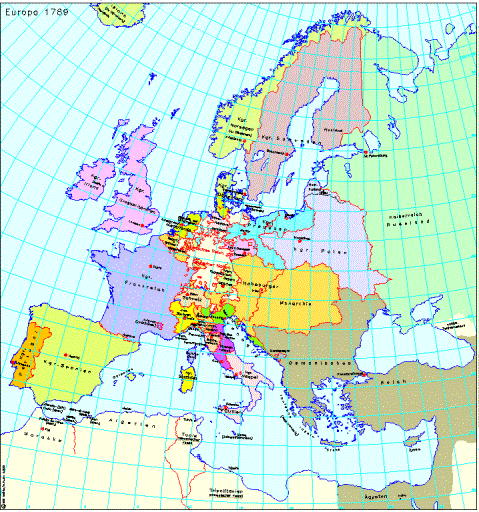
Map 1: Europe 1789
The map shows the territorial order of Europe in 1789, the year of the French Revolution. The political landscape of Europe at the end of the Ancien Regime was characterised by the existence of large territorial states, which were also Great Powers, among them Russia, Great Britain, France and the Ottoman Empire. Although Prussia and the Habsburg Monarchy were in appearance large states (and Great Powers), they were also part of the Holy Roman Empire of the German-speaking Peoples, the Old EmpireÎ, whose territory stretched from the Holstein in the north to Triest in the south and from the Belgian coast in the west to Upper Silesia in the east. Of the numerous (around 2000) members of this Empire only the largest are represented on the map. Apart from Prussia and the Habsburg Monarchy these included the elector states of Bavaria, Saxony and Hanover. Italy was similarly divided. Alongside the Kingdoms of Naples and Sicily, the Kingdom of Sardinia (including the Savoy), the Republic of Venice and the Papal State, there were numerous small states. The territorial relationships of these two divided European regions will be more clearly represented in the European Great RegionsÎ series. Apart from the great territorial states that were also Great Powers, there was also a range of states that had once possessed Great Power status, but whose political and military importance in 1789 was such that they can only be described as middle-ranking powers. These middle-ranking powers included Poland, which had been reduced in size by the first partition of 1772, Spain, Portugal, Sweden and Denmark. Denmark along with Norway and Iceland and the Duchies of Schleswig and Holstein made up a confederation of states.
© IEG / A. Kunz
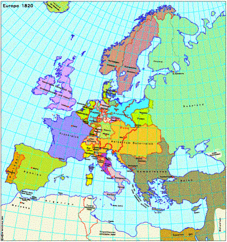
Map 2: Europe 1820
The map shows the political re-organisation of Europe as decided at the Congress of Vienna in 1815 and consolidated in subsequent years. The post-Revolution and post-Napoleon restoredÎ Europe differed significantly from the Europe of 1789. In place of the Old EmpireÎ there was now a German ConfederationÎ, a loose association of states to which forty German states as well Austria, Luxembourg and Denmark belonged. While Italy remained fragmented, in northern and western Europe large national states had been formed: France, Spain and Portugal, Great Britain, Sweden and Norway (united until 1905 by a personal union). The borders of these states scarcely changed in the following decades. Eastern and southeastern Europe was also shaped by large territorial states. However, these were not national states, but rather three politically heterogeneous EmpiresÎ: the Austrian Empire, the Russian Empire and the Ottoman Empire. In the southeast the borders were especially subject to change between 1820 to 1914 following the dissolution of the Ottoman Empire and the formation of national states.
© IEG / A. Kunz 2003